Archive for the Urban Geography Category

Baby Boomers, Gentrification and Re-urbanization in Melbourne, AU

Posted in Population Geography, Urban Geography on November 25, 2008 by geography101

Shepard Simpson from our class provides a lucid account of an aspect of gentrification and re-urbanization that we didn’t touch on in lecture. Its not just young professionals who are moving back to the city to take advantage of its new creative enterprises, but also the ‘baby boomers’. As Shepard notes below, many of these ’empty nesters’ like those of her parents generation, are also returning to the city, contributing to its rapid transformation:

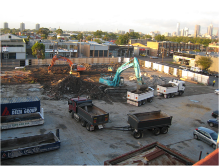
skyline1The first picture is from the balcony of my parents’ apartment, taken about a year ago when I was home for winter break. My parents live in Melbourne, Australia and had just recently moved from a suburb of Melbourne to a place which is a ten minute walk to downtown (the beauty of being empty nesters). The following picture depicts an office complex that has been built during the past year right next door. These pictures made me think about the process of urbanization we have been discussing in class, and the idea of an “aging population” resulting from the approaching retirement of the baby boomer generation which we discussed in discussion sections during our second round of debates.construction1

The area which my parents moved to used to be the industrial sector made up of strings of warehouses that lined the Yarra River. Over the past few decades, these warehouses have been either torn down and/or renovated into new modern apartment complexes and huge infrastructure projects. More and more people are relocating to the area because of its proximity to downtown and its location on the river. In my opinion this is a prime example of Gentrification and “Re-urbanization”. The picture also made me start thinking about how the restructuring of cities and the outmoded concept of “Levittown” is in large part connected to the “soon to come” retiring group of baby boomers. I think it is going to be interesting to observe over the next couple decades how urban geographies continue to evolve and in turn what affects this will have on suburban life. 
National symbol of American Dream is a foreclosure hotspot

Posted in Economic Geography, Political Geography, Urban Geography on November 19, 2008 by geography101
Levitt and Sons filled for bankrupcy in 2007

Levitt and Sons filed for bankruptcy in 2007

An op-ed piece in today’s New York Times notes that in Levittown, empty houses and for sale signs are shattering enduring images of the post-war suburban dream. In Long Island, the home of Levittown, about 1 in 3 mortgages were sub-prime:

“[Foreclosures] may seem to be a problem for overbuilt exurbs, go-go condo zones and McMansion sprawl — not tidy, solid communities like Levittown, where the American Dream was invented.”

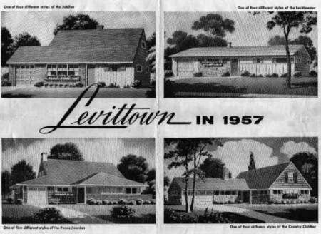
Levitt and his sons revolutionized homebuilding over 50 years ago through a combination of technological innovations and mass production. Levittown became the pinnacle of a society driven by middle class consumption. As the largest all-white community in the nation in 1960 (today it’s 94 % white), it also speaks volumes to the social geographies produced through the federally administered race-restricted mortgages of that era. Last year, Levitt and Sons filled for bankruptcy protection after its investments in Florida’s housing markets collapsed. Read the full story from the New York Times here

The Top Ten Influences on the American Metropolis of the Past 50 Years

Posted in Urban Geography on November 11, 2008 by geography101

picture-12

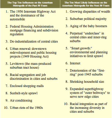
Robert Fishman, influential urban historian, conducted a survey at the end of the last millennium of members of the Society for American City and Regional Planning History (SACRPH) to compile a list of the top ten influences on America cities over the past 50 years. The list (on the far left) begins with the 1956 Interstate Highway Act and ends with the urban riots of the 1960s. On the column to the right, the Society’s predicts the biggest influences on cities in the coming 50 years. They predict growing polarization, the internet and the decline of the post-war suburbs will be among the major influences on cities in the new millennium. The report was written in 1999. Nearly ten years into this new age, how accurate have their predictions been? What is missing from the list? How has 9/11 influenced urban life? Read the full report here

Urban polarization in US rivals cities in the global south, UN report says

Posted in Urban Geography on November 10, 2008 by geography101

A report released by the United Nations last month suggests that inequality in New York, Washington, Atlanta and New Orleans rivals that of some cities in Africa. The report, which reviewed economic inequality in cities around the world says that in both Canada and the US, a key factor determining poverty levels is race. According a review of the report in the International Herald Tribune, 

[t]he life expectancy of African Americans in the United States is about the same as that of people living in China and some states of India, despite the fact that the United States is far richer than the other two countries.

Read about the UN report State of the World’s Cities 2008/2009 here

Mumbai: everyday contradictions of urbanization and globalization

Posted in Geography and Globalization, Urban Geography on November 10, 2008 by geography101

09worldxlarge2A recent essay by Anand Giridharadas speaks volumes to the contradictions of Mumbai in the face of urbanization and globalization. This is a city where “luscious skyscrapers sprout beside mosquito-prone shantytowns”; where Bollywood–India’s answer to Hollywood–meets Dharavi, a slum where one million people inhabit one square mile. Giridharadas remarks that “these dueling claims on Mumbai explain its mongrel look: like a duty-free mall in parts, in parts like a refugee camp.”

What does it mean to be an emerging global city and home to one of the largest slums in Asia? What do plans for Dharavi’s redevelopment have to do with the need for cities to compete in an increasingly globalized marketplace? Processes of displacement within the context of urban redevelopment are not confined to places like Mumbai. As we begin our discussion of urbanization and gentrification we’ll begin to see similarities between what’s happening in Mumbai and Dharavi and cities in the western world. Read Giridharadas’ story, published along with a slide show, in the New York Times here

Population growth and the changing story of Milwaukee, a ‘city of immigrants’

Posted in Population Geography, Urban Geography on November 5, 2008 by geography101

Dave Steel, an urban planner in Milwaukee notes that of all the statistics used to gauge the health and well being of a city, “we put the most stock in population growth or decline”. In a recent article posted in the Next America City he writes:

A city’s population growth or decline, as reflected in Census estimates and decennial counts, influences a lot of consequential decisions, from the allotment of governmental resources, to the location decisions of corporations. And, perhaps more importantly, population counts help form a city’s narrative, the story it tells about itself. Growing cities are said to be prosperous and thriving; shrinking cities are said to be in decline.

hmong2101804kids

Ethnic Hmong children play on Milwaukee's South Side

Based on recent estimates from US Census data, the population of Milwaukee appears to be growing after years of steady decline. While the details about who exactly is fuelling this growth won’t be known until the 2010 Census, Steel’s seasoned eye suggests it may be a result of recent immigrants from South Asia, as well as a booming Latino population. The story of the city’s changing ethnic composition can be read on a stroll through its South Side. These new arrivals, Steel notes, continue to reshape Milwaukee’s historic tradition as a ‘city of immigrants’:

josaphat-basilica

St Josaphat Basilica on the South Side. It was built by Polish immigrants at the end of the 19th century

Like the Germans, Poles, Irish and Italians before them, today’s Latinos and Hmong are staking their claim in a city that has always taken both the unskilled and uneducated into its ranks. What’s less certain, however, is whether the new Milwaukee can offer its new residents what the old Milwaukee did: the good jobs and good schools necessary for immigrants to work their way into the middle class. With more residents comes a greater responsibility to provide those services that are essential for a productive life.

Read the full story from the Next American City here

Here is a link to another article from the Journal Sentinel, documenting patterns of ethnic change in the city.

Conflicts between urban and federal governments emerge on how to address undocumented migrants in US

Posted in Population Geography, Urban Geography on November 4, 2008 by geography101
haven190

Gathering of residents of New Haven after the immigration raid by the feds

We’ve been talking in class about some of the steps local municipalities and counties are taking to address issues relating to undocumented migrants. Eric Grazia, from our class sent this story which deals directly with this issue. He writes:

“I’m from a small town outside of New Haven, Connecticut. In 2007 New Haven introduced ID cards which allow illegal immigrants to open bank accounts and get access to other services. New Haven was the first city in the nation to do this. There was a raid by the federal government two days after the policy went into affect, clearly in retaliation to the policy.”

An article in the New York times in 2007 discusses the policies adopted by the city. In addition to these immigration cards issued by the municipality, local police adopted a “don’t ask, don’t tell” policy, meaning that they would not question an individual’s citizenship status for any reason. According to the New York Times, after the raid by the federal government, the Mayor

“and other city leaders angrily accused the federal government of “terrorizing” the immigrant community. Many of them speculated that the mass arrests — the first of their kind in recent memory here — were retaliation for the acceptance of municipal identification cards and other immigrant-friendly city policies.”

Read the full story here.


Heavy Metal in Baghdad: war, migration, culture

Posted in Cultural Geography, Geography and Globalization, Population Geography, Urban Geography on October 30, 2008 by geography101
Feature length film released in 2007

Feature length film released in 2007

Nate Millington alerted us to this film released last year which centres on one of the few (only?) heavy metal bands inBaghdad. Through the story of the band, the film Nate writes, “deals with a lot of issues related to cultural communities and migration, in particular. It ties in really directly to [migration and refugees] and gives a really strange, but ultimately compelling, look at Iraqi migration and the war.” See trailers and read reviews of the film, which premiered at the Toronto and Berlin International Film Fests last year, here.

Effects of the US Census: Prison-based electoral politics grows as number of inmates around the nation balloons

Posted in Population Geography, Urban Geography on October 25, 2008 by geography101
Ward two in Anamosa has all the benifits of a city council seat, but only 58 constituents. The rest are in prison.

Ward two in Anamosa has all the benefits of a city council seat, but only 58 constituents. The rest are in prison.

The US incarcerates more people than any other country in the world. About 1 in every 37 adults in the US is in prison. Rates are even higher if you are a person of colour, particularly a male. The prison population is counted in the US census. Counting prisoners in the US census but not on the ballot box can have severe effects. While this may not have posed as big of a problem in years past, when incarceration rates were much, much lower, its having huge ramifications today, in everything from how state funding is allocated, to how electoral boundaries are drawn.  The New York Times ran a story this week about an election in Anamosa, Iowa where Danny Young was elected as a representative to city council on a total of 2 votes. The reporter explains: “That is because his ward includes 1,300 inmates housed in Iowa’s largest penitentiary — none of whom can vote. Only 58 of the people who live in Ward 2 are nonprisoners”. Similar occurances are happening in Wisconsin, Tennessee, and New York. Read the full story

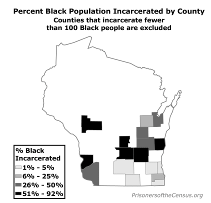
Electoral politics are not the only thing affected from the booming prison population. In addition to a high incarceration rate, the US incarcerates a disproportionate number of people of color. In Wisconsin, incarceration rates for blacks are nearly twelve times higher than for whites. The Prison Policy Initiative (PPI) reports that this has affected the distribution of funds, often from urban communities of colour to rural an prison communities. Read an except from their 2004 report below:

Pecentage of Black Population Incarcerated in Wisonsin by county

Pecentage of Black Population Incarcerated in Wisconsin by county

“According to the census, Dodge County has a black population of 2,142 people. Without doing any research beyond the statistics delivered to us from the latest census, one might conclude that there has been a rise in communities of color within this predominantly rural county. However, after looking closer, we realize that 89 percent (1,196 persons) of the black population within Dodge County is incarcerated. The county is the site of two major state prisons, the Fox Lake Correctional Institution and Waupun Correctional Institution.

According to Peter Wagner, director of the PPI, this type of redistribution of the population “impacts how redistricting and political power is exercised in the state.” As a “demographic distortion”, it affects both urban and rural communities. He notes: “These demographic distortions affect both urban and rural communities due to this confluence of increasing prison population and growing rural unemployment, as population-scaled federal and state funds are tipped towards rural prison communities and away from urban communities of color.” Follow this link to the full report.

Urban Earth

Posted in Urban Geography on October 25, 2008 by geography101


Daniel Rosinsky-Larsson from our class sent in this really interesting project–Urban Earth– that he featured recently on WPR. The project is run by a geography professor from England, who, in colaboration with local residents, walks through various cities–from London, to Guadalajara, to Mexico and Mumbai–from end to end, choosing a path which takes them through diverse socio-economic areas. To document their walk, they take a photograph every 8 steps. Sounds facinating! You can listen to a podcast that Daniel produced on the Urban Earth right here